Log in
All resources
Create a design
887 Free Artworks of Old Maps Of France
bibliothèque nationale de france
maps in the rijksmuseum amsterdam
maps by carolus allard
géographie illustrée de la france et de ses colonies
abraham allard
philippe de la rué
guillaume sanson
etchings of ports and harbours
old maps of norway
illustration
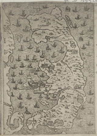
maps of the islands of greece by marco boschini (1658)
old maps of the lesser cyclades
chorographia britanniae (1741-1742)
18th-century maps of lancashire
russo-turkish war (1877–1878) in art
great eastern crisis (1875–78)
old maps of the battle of waterloo
achille tenaille de vaulabelle
old maps of kollam
catherine haussard
maps by willem and johannes blaeu
old maps of westmorland
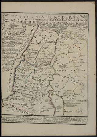
maps of ancient israel by philippe de la rué
old maps of the tribes of israel
toledo, spain in the 17th century
old maps of toledo, spain
map of ancient assyria by philippe de la rué
old maps of mesopotamia
old maps of oxfordshire
maps by thomas kitchin
maps by thomas kitchin
old maps of hampshire
maps of paris from the david rumsey historical map collection
maps of île-de-france by françois de la guillotière
géographie illustrée de la france et de ses colonies
old maps of moselle
géographie illustrée de la france et de ses colonies
old maps of meurthe (department)
géographie illustrée de la france et de ses colonies
old maps of gironde
atlas ou representation du monde universel t. 1 (1633)
old maps of beauvais
atlas ou representation du monde universel t. 1 (1633)
maps of france by hendrik hondius
atlas ou representation du monde universel t. 1 (1633)
old maps of languedoc
old maps of plymouth and devonport
jan van doetechum
old maps of norway
guillaume sanson
1720s maps of palestine
nicolas de fer
utrecht (city) in the 17th century
joost cornelisz. droochsloot
maps of ancient israel by philippe de la rué
old maps of the stations of the exodus
considérations géographiques et physiques sur les nouvelles découvertes au nord de la grande mer
old maps of the yellow sea
napoleon i of france in art
academic art
atlas, ou représentation du monde universel et des parties d'icelui, faicte en tables et descriptions très amples et exactes, divisé en deux tomes. édition nouvelle... - btv1b53103889w
maps facing west
topographischer atlas der schweiz
old maps of geneva
old maps of regensburg
baroque
old maps of curaçao
johannes leupenius
map of ancient assyria by philippe de la rué
old maps of mesopotamia
old maps of norway
guillaume sanson
géographie illustrée de la france et de ses colonies
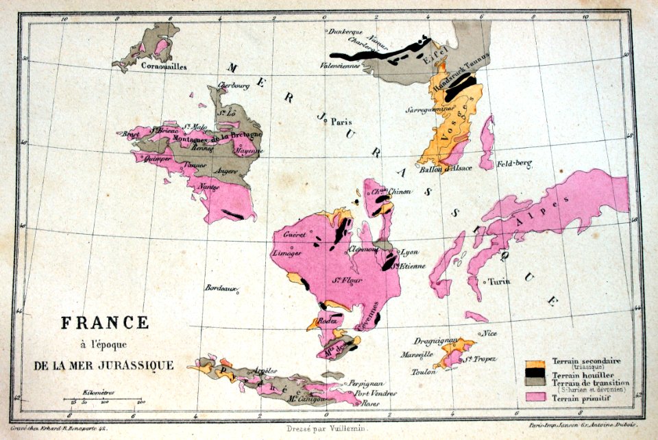
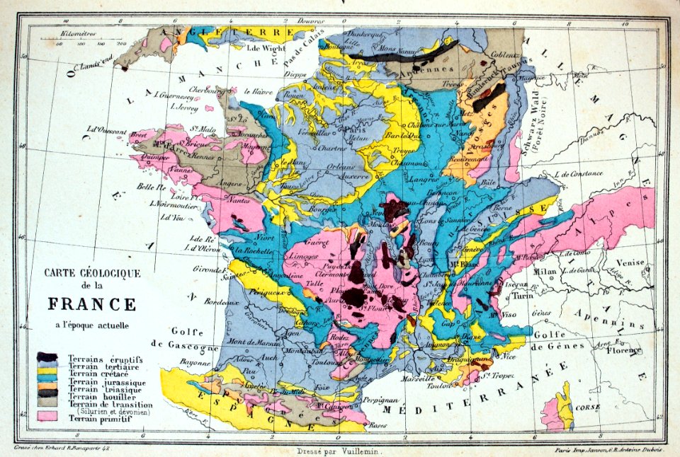
old maps of france
old maps of norway
guillaume sanson
old maps of norway
guillaume sanson
géographie illustrée de la france et de ses colonies
old maps of france
old maps of the franco-prussian war
alfred quesnay de beaurepaire
plan de paris levé par les ordres du roy, 1900
proletarian literature
maps of ancient israel by philippe de la rué
old maps of the stations of the exodus
old maps of norway
guillaume sanson
géographie illustrée de la france et de ses colonies
old maps of allier
david rumsey historical map collection
old maps of the holy roman empire
old maps of duchy of cleves
guillaume sanson
maps by abraham ortelius
pieter van der keere
géographie illustrée de la france et de ses colonies
orientalist painting
géographie illustrée de la france et de ses colonies
orientalist painting
old maps of scotland from the norman b. leventhal map center
old maps of ireland from the norman b. leventhal map center
maps of ancient israel by philippe de la rué
old maps of the united monarchy
history of avignon
atlas van loon
illustration
maps
old maps of mainz
baroque
het uuterste ofte oosterste deel van de oster zee, beslooten tegens ruslandt lijfflandt, oost finlandt, in welcken de twe opperste ofte veerste laetplaetsen sijn van de geheele oosterse navigatie, te weeten... - btv1b53235861c
old maps of the gulf of finland
old maps of bologna
gregorio monari
old maps of the american civil war
1861 maps
illustration
book
old maps of lyon
simon maupin
prints by abraham allard in the rijksmuseum amsterdam
1700s maps of spain
illustration
book
illustration
book
illustration
book
dutch 18th-century prints in the rijksmuseum amsterdam
symbols of roermond
dutch 18th-century prints in the rijksmuseum amsterdam
old maps of roermond
cádiz in the 18th century
old maps of cádiz
maps in the rijksmuseum amsterdam
maps by carolus allard
maps in the rijksmuseum amsterdam
1690s maps of the netherlands
prints by abraham allard in the rijksmuseum amsterdam
1726 maps of spain
maps of the captaincy general of cuba
maps of the history of florida
maps in the rijksmuseum amsterdam
old maps of barcelona
maps in the rijksmuseum amsterdam
old maps of barcelona
etchings in the rijksmuseum amsterdam
maps in the rijksmuseum amsterdam
prints by abraham allard in the rijksmuseum amsterdam
maps in the rijksmuseum amsterdam
les forces de l'europe, asie, afrique et amerique, ou description des principales villes, avec leurs fortifications
maps in the rijksmuseum amsterdam
claude auguste berey
henri liébaux
4 gravures représentant la guerre entre les vénitiens et les turcs autour de corfou sur une feuille - btv1b8493378g
old maps of corfu
4 gravures représentant la guerre entre les vénitiens et les turcs autour de corfou sur une feuille - btv1b8493378g
old maps of corfu
4 gravures représentant la guerre entre les vénitiens et les turcs autour de corfou sur une feuille - btv1b8493378g
old maps of corfu
cádiz in the 18th century
old maps of cádiz
thomas onwhyn
britannia
etchings in the rijksmuseum amsterdam
maps in the rijksmuseum amsterdam
les forces de l'europe, asie, afrique et amerique, ou description des principales villes, avec leurs fortifications
old maps of perpignan
maps of paris from the david rumsey historical map collection
maps of paris by braun & hogenberg
old maps of the viceroyalty of new spain
the spanish borderlands
photographs of prison saint-lazare in musée carnavalet
photographs of prison saint-lazare in musée carnavalet
drawings of paris by alfred bonnardot
floor plans in musée carnavalet
les forces de l'europe, asie, afrique et amerique, ou description des principales villes, avec leurs fortifications
old maps of île de ré
les forces de l'europe, asie, afrique et amerique, ou description des principales villes, avec leurs fortifications
old maps of cádiz
photographs of prison saint-lazare in musée carnavalet
801 - 887 of 887
/ 9

![Isolette [Raclia, Schinussa, etc] / Marco Boschini, 1658](https://cdn.creazilla.com/illustrations/10000518565/isolette-raclia-schinussa-etc-marco-boschini-1658-sm.webp)


![Gerardi Mercatoris and I. Hondii Atlas or Representation of the Universal World, and of the Parts of It, Made in Tables and Descriptions Very Ample, and Exact: Divided into Two Volumes [...]. [t. 1].](https://cdn.creazilla.com/illustrations/10000289508/gerardi-mercatoris-and-i-hondii-atlas-or-representation-of-the-universal-world-and-of-the-parts-of-it-made-in-tables-and-descriptions-very-ample-and-exact-divided-into-two-volumes-t-1-sm.webp)
![Gerardi Mercatoris and I. Hondii Atlas or Representation of the Universal World, and of the Parts of It, Made in Tables and Descriptions Very Ample, and Exact: Divided into Two Volumes [...]. [t. 1].](https://cdn.creazilla.com/illustrations/10000315820/gerardi-mercatoris-and-i-hondii-atlas-or-representation-of-the-universal-world-and-of-the-parts-of-it-made-in-tables-and-descriptions-very-ample-and-exact-divided-into-two-volumes-t-1-sm.webp)
![Gerardi Mercatoris and I. Hondii Atlas or Representation of the Universal World, and of the Parts of It, Made in Tables and Descriptions Very Ample, and Exact: Divided into Two Volumes [...]. [t. 1].](https://cdn.creazilla.com/illustrations/10001441154/gerardi-mercatoris-and-i-hondii-atlas-or-representation-of-the-universal-world-and-of-the-parts-of-it-made-in-tables-and-descriptions-very-ample-and-exact-divided-into-two-volumes-t-1-md.jpg)


![Map of Thrace to aid in understanding Roman history / by Henri Liébaux, geographer; C[laude] A[uguste] De Berey, sculp[sit], Claude Auguste Berey, 1727](https://cdn.creazilla.com/illustrations/10001256073/map-of-thrace-to-aid-in-understanding-roman-history-by-henri-libaux-geographer-claude-auguste-de-berey-sculpsit-claude-auguste-berey-1727-md.jpg)